
Easily Survey Large Sites
Our drones enable you to quickly generate a topographic survey of any site, even one which is inaccessible. With a few taps on a tablet, anyone of your team can generate orthophotos, point clouds, and meshes, which are used to build design surfaces and contours. Commissioning regular surveys for large areas would be logistically impossible, but a drone can generate the exact same deliverables in a fraction of the time.
Why Hawk?
Generate aerial photography and topographic surveys on any site with a touch of your tablet.
With our drone, you can input ground control points to provide your clients with accurately geolocated point clouds and orthophotos, ensuring your client deliverables measure up to your high standards.
Fast-moving earthworks projects require the daily attention of the civil engineer, constructor, and landscape architect. With our drones you can generate the exact same location imagery every day and at the fraction of the time
Solutions
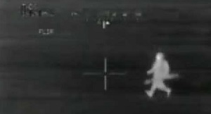
Conservation Monitoring
Drone photography and video has revolutionised environmental conservation efforts. Such systems are being used across the world to help protect endangered and protected species as well as to monitor reserves for any unusual activity.